Language
Python
Tool Type
Algorithm, API, Web app
License
The 2-Clause BSD License
Version
1.0
Undersecretariat of Evidence-Based Public Policies, Government of the City of Buenos Aires
.png)
3D City is a platform that allows you to view the Buenos Aires Urban Code through three-dimensional representations, showing what constructions are possible on different plots. This tool is useful for both urban developers and residents, clarifying the limits and possibilities established by the code. This platform was developed to simplify and speed up the application of the Urban Planning Code. By making urban planning regulations transparent, 3D City facilitates the presentation of projects and promotes urban development that is more understandable and accessible to all.
3D City addresses the complexity of understanding the Urban Code, offering a visual solution that simplifies the interpretation of regulations for developers and citizens, accelerating the presentation of adapted urban projects.
3D interactive map of Buenos Aires. Utilizes geospatial data for accurate representation. Aids in urban planning and management. Provides insights into city structure.
Web application integrating mapping technologies and geospatial data. Focused on interactive visualization and navigation of urban environments in 3D.
Connect with the Development Code team and discover how our carefully curated open source tools can support your institution in Latin America and the Caribbean. Contact us to explore solutions, resolve implementation issues, share reuse successes or present a new tool. Write to [email protected]
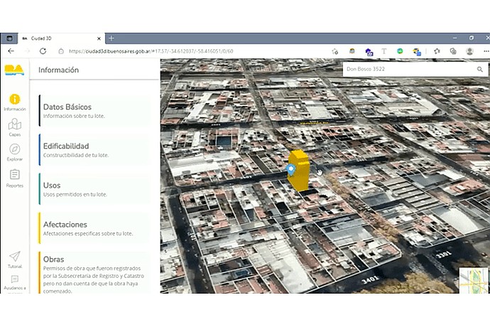
3D aerial view of a neighborhood with a building highlighted in yellow. On the left side, the menu has options: Information, Basic Data, Buildability, Uses, and Affects. Street: Don Bosco 3522.
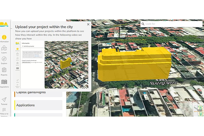
The image displays a 3D model of a yellow building on an aerial city map. The left menu shows options like "Information", "Layers", and "Explore". Visible addresses include "Yrigoyen, Hipólito Av." and "Belgrano".
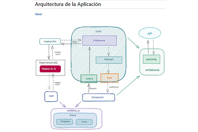
"City 3D" architecture diagram shows an interaction flow between components: API, Mapbox GL JS, Ducks (middleware, reducers, actions, state), components, Material-UI, and app configuration.
Presentation of the functionalities and improvements incorporated into the 3D City platform.
Tool page on the official website of the government of the city of Buenos Aires.
Digital tool that allows you to visualize in three dimensions the buildable areas and maximum heights allowed on each plot of the City of Buenos Aires.