
Language
CSS
Tool Type
Web app
License
AM331-A3
Version
1.0.0
Inter-American Development Bank

Tourism and Leisure Route is a solution designed to optimize the cycling network in cities, focusing on the interaction between permanent and operational cycling networks. Its purpose is to extend the sections for cyclists, especially during Sundays and holidays, thus facilitating access to the main urban tourist spots. This tool supports the Ministry of Tourism in the planning and execution of temporary cycling networks, ensuring broad and strategic coverage that connects tourist attractions. In addition, it promotes the use of data to improve decision-making in the tourism field, contributing to more efficient and user-oriented management.
Carry out a detailed count of the points where permanent and temporary cycling networks intersect; Collaborate with the Ministry of Tourism to plan and execute the operational bicycle network, thus connecting the most important tourist sites in the city.
Intersection Accounting: One of the key objectives is the accounting of intersection points between the permanent and operational bicycle network. This likely helps identify key areas where networks connect and can be optimized. Assistance to the Ministry of Tourism: The solution also seeks to assist the Ministry of Tourism in the formulation and implementation of the operational bicycle network. This has the specific purpose of connecting the main tourist attractions of the city, thus improving the tourist experience and promoting the use of bicycles as a sustainable means of transport. Reason for Development and Sharing: The solution was developed with the objectives mentioned above, especially to improve the integration of cycling networks and support tourism. It is shared in order to promote the application of data in decision making within the tourism sector. This suggests a focus on using data analytics and technology to improve urban and tourism planning, especially as it relates to mobility and leisure.
Built with R: leverages Shiny for developing interactive web applications. Provides a dashboard structure using ShinyDashboard and ShinyDashboardPlus for advanced features. Incorporates Shinywidgets and Camador to customize the interface and enhance user experience. Facilitates functional programming with PURRR and data management with data.table and dplyr. Supports spatial operations and geospatial data visualization through Folleto, Geojsonsf, and SF. Enables string and date manipulation with StringR and Lubridate.
Connect with the Development Code team and discover how our carefully curated open source tools can support your institution in Latin America and the Caribbean. Contact us to explore solutions, resolve implementation issues, share reuse successes or present a new tool. Write to [email protected]
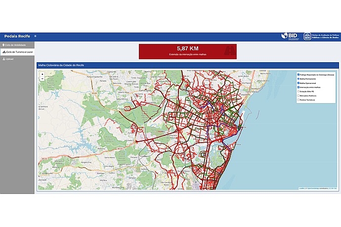
Bike lanes map in Recife with red and green routes. Red text indicates "5.87 KM Mesh Intersection". Options: reported traffic, operational mesh, points of interest. IDB logo visible.
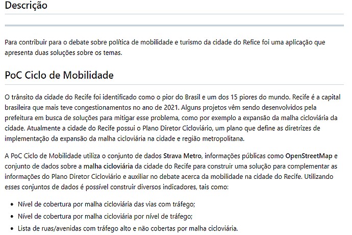
This image contains text describing a Proof of Concept (PoC) for Mobility Cycle, discussing traffic issues in Recife and solutions involving cycling infrastructure.
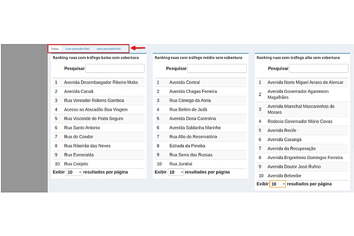
"Tourism and Leisure Route" screen with street rankings by PDC uncovered traffic. There are three lists: low, medium, and high traffic with search engines and an option to display 10 results per page.
IDB Technical Cooperation to support Brazilian cities with data-based tools.