
Language
Docker
Tool Type
Algorithm, API, Desktop app
License
The MIT License
Version
1.0.0
Flowminder

FlowKit is a platform that analyzes call logs from mobile network operators to handle situations such as natural disasters and epidemiological crises. It uses high standards of security and data protection to transform information into crucial tools for decision making. This open source API enables restricted and secure access, crucial for operations that can save lives or improve emergency services.
FlowKit solves the need to use telecommunications data safely and effectively, allowing analysis in critical situations such as natural disasters and monitoring of population movements, optimizing responses and resources in crises.
Data Import and Cleaning: Allows users to import and clean large-scale population mobility datasets. Spatial Analysis: Provides tools for geospatial analysis to understand migration patterns and trends. Data Visualization: Offers visualization capabilities to create maps, charts, and graphs for insights. Demographic Analysis: Enables users to analyze population demographics and characteristics. Data Integration: Supports the integration of various data sources to enrich migration studies. Export and Sharing: Allows users to export analysis results and collaborate with other researchers. Data Privacy: Ensures data privacy and security standards are met for sensitive information.
Developed primarily in Python, it leverages its open-source ecosystem. Utilizes Pandas and Numpy for efficient data manipulation. Incorporates geospatial libraries such as Geopandas and GDAL for advanced analysis. Uses matplotlib and seaborn for clear and effective data visualization. Supports integration with databases like PostgreSQL and SQLite, ensuring interoperability. Handles multiple data formats, including CSV, Excel, and spatial formats, facilitating compatibility. Provides detailed documentation for users and developers.
Connect with the Development Code team and discover how our carefully curated open source tools can support your institution in Latin America and the Caribbean. Contact us to explore solutions, resolve implementation issues, share reuse successes or present a new tool. Write to [email protected]
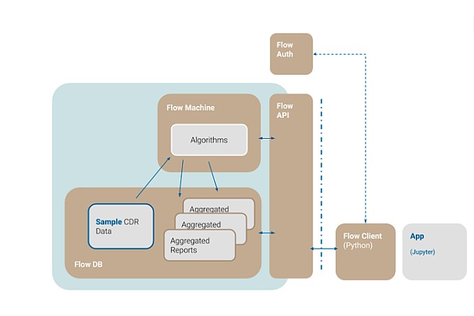
This image illustrates a data flow diagram, detailing the process from sample CDR data through a 'Flow Machine' with algorithms to aggregated reports, interfacing with an API.
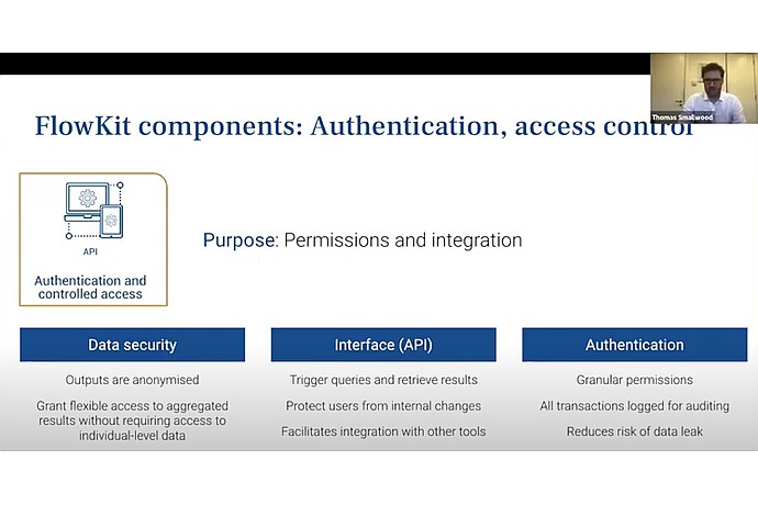
This image displays a presentation slide about FlowKit components, focusing on authentication and access control for data security, API integration, and transaction auditing.
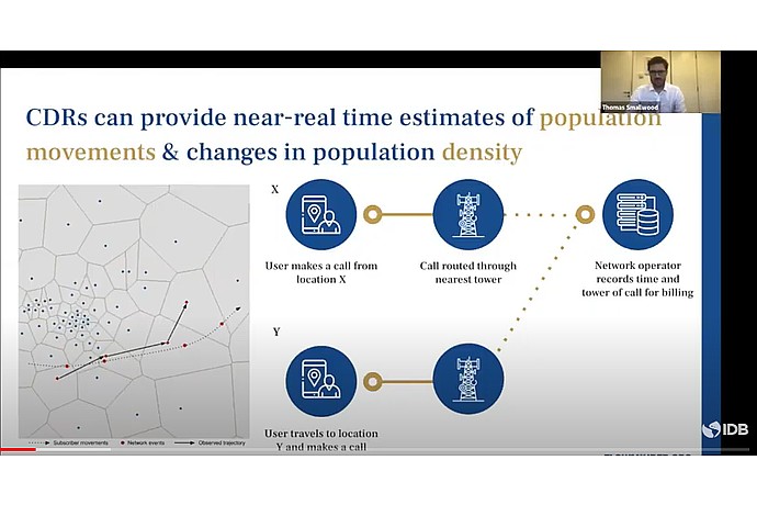
This image presents a slide explaining how Call Detail Records (CDRs) can be used to estimate population movements and changes in population density in near real-time.
Suite of open source tools for the secure analysis of mobility data from mobile operators.
Official list of open source tools endorsed by the Digital Public Goods Alliance. This tool is part of this registry.
Article that presents the global alliance to promote digital public goods and its relationship with the IDB.
Complete guide on the features and use of FlowKit.