
Language
R
Tool Type
Algorithm
License
AM331-A3
Version
1.0.0
Inter-American Development Bank

The "Housing Deficit Estimation" tool applies an advanced methodology to analyze the housing deficit, both quantitative and qualitative, using census data. Using association analysis, it identifies patterns in the conditions that contribute to the qualitative deficit and uses satellite imagery for estimates in years without census data. In Guyana, this tool played a crucial role in providing updated data for the National Housing Strategy, leveraging satellite imagery to assess the housing deficit in 2019. Its ability to define and determine the housing deficit, identify patterns of qualitative deficit and predict deficit levels without recent census data, makes it a valuable resource for government decision-making.
The tool addresses the challenge of assessing and understanding housing deficits within a region or area. Provides a structured framework for estimating housing deficits and informing housing policies to improve housing accessibility and affordability.
Housing Deficit Assessment: The tool supports the assessment of housing deficits, considering various factors and demographics. Data Analysis: Users can perform data analysis related to housing deficits and housing needs. Policy Recommendations: Housing Deficit Estimation provides insights and recommendations for housing policy planning.
Uses georeferenced census microdata and shapefiles to calculate housing deficit indices. Employs R and custom scripts to adapt the analysis across countries, considering materials, services, and density.
Connect with the Development Code team and discover how our carefully curated open source tools can support your institution in Latin America and the Caribbean. Contact us to explore solutions, resolve implementation issues, share reuse successes or present a new tool. Write to [email protected]
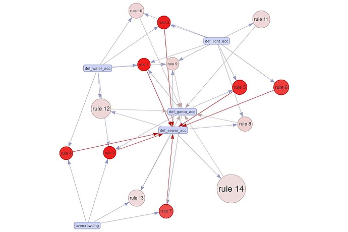
This image depicts a network graph with nodes labeled as "rules" and "deficiencies" (like water, garbage, sewer) connected by edges, possibly showing correlations or dependencies.
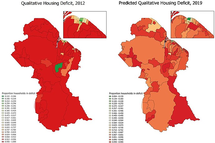
Two maps show the qualitative housing deficit in a region in 2012 and 2019. In 2012, dark red dominates, indicating high deficit. By 2019, more areas appear in lighter shades.
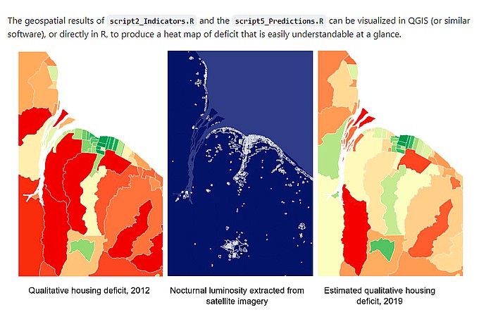
This image presents three heat maps: housing deficit in 2012, nocturnal luminosity from satellites, and estimated housing deficit in 2019, showing geospatial data analysis results.
It presents a set of open source tools from the IDB, including housing deficit estimation, to support urban planning in Latin America and the Caribbean.
Code4Dev Webinar: Learn about Estimating the Housing Deficit
Support for housing strategy in Guyana.