
Language
Docker
Tool Type
Algorithm
License
AM331-A3
Version
1.0.0
Inter-American Development Bank

MAIIA is a library of algorithms designed to automatically identify informal urban settlements through the analysis of satellite images. It uses a pre-configured operating system image and scripts to train and apply a detection model in two easy steps, making it easy to deploy. Developed by GIM in collaboration with the Housing and Urban Development Division of the IDB, MAIIA was created to assist the National Planning Department of Colombia. Its objective is to provide a tool capable of generating and updating detailed maps of informal settlements, reducing barriers to access to artificial intelligence and allowing its use by government agencies, researchers and other stakeholders.
The development of MAIIA addresses the critical challenge of accurately mapping and understanding urban informal settlements. Traditional mapping methods are often inadequate to capture the complexity and dynamics of these areas. The need for a tool capable of analyzing vast satellite images to identify informal settlements is crucial for urban planning and policy formulation, especially in resource-limited areas. The ability to generate and update accurate maps of these settlements is essential for effective urban development strategies, resource allocation and infrastructure planning in rapidly growing urban areas.
Analyzes satellite imagery to map informal urban settlements automatically. Implements a pre-configured Docker image for easy deployment and use. Includes scripts for training AI models and applying them to new images. Utilizes open-source technologies for enhanced functionality and accessibility. Suitable for various stakeholders in urban development and housing.
Built with Python, it ensures flexibility and broad applicability. It employs machine learning and deep learning frameworks like Tensorflow to enhance its capabilities. Facilitates large-scale image processing using Satproc and UnetSeg. Provides a Docker-based solution that simplifies installation and enhances scalability. Promotes interoperability and the use of open formats in urban and housing development.
Connect with the Development Code team and discover how our carefully curated open source tools can support your institution in Latin America and the Caribbean. Contact us to explore solutions, resolve implementation issues, share reuse successes or present a new tool. Write to [email protected]
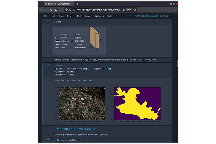
Screenshot of a Jupyter Notebook showing Python code that loads and displays a data array. Includes graphics of a satellite map and its purple-colored mask.
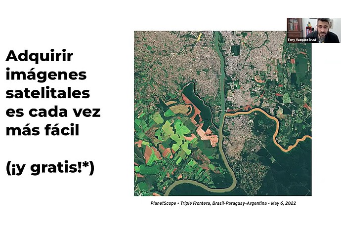
This image displays a presentation slide stating "Acquiring satellite images is increasingly easy (and free!)*" with a satellite image of the Triple Frontier, dated May 6, 2022.
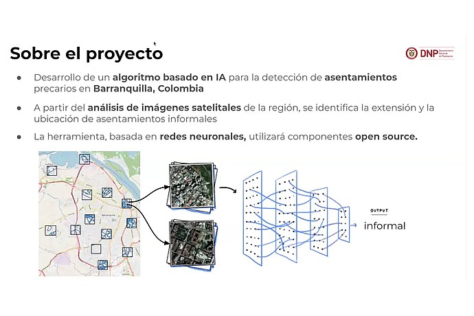
This image presents information about a project that involves developing an AI algorithm to detect informal settlements in Barranquilla, Colombia, using satellite imagery and neural networks.
It presents a set of open source tools from the IDB, including housing deficit estimation, to support urban planning in Latin America and the Caribbean.
Code4Dev Webinar: Learn how to implement the MAIIA open source tool
Promotes the use of digital tools in urban planning and transit in LAC.
Discusses the use of MAIIA to map informal settlements in Colombia.
Highlights urban case studies in Latin America and the Caribbean, including the use of the MAIIA tool.