
Language
Python
Tool Type
Algorithm, Manual
License
AM331-A3
Version
1.0.0
Inter-American Development Bank

Matriz OD Transporte Público offers a set of detailed data on the stages and trips made by public transportation, using the SUBE card in the Metropolitan Region of Buenos Aires. This resource includes both the raw data and the scripts necessary to process and link travel stages, in addition to imputing destinations, facilitating a comprehensive analysis of urban movement. This resource is essential for the development of public transportation policies, providing a database that reflects mobility patterns. The information, obtained anonymously, allows governments, NGOs, and other civil society actors to participate in debates about public transport planning, ensuring that decisions are based on representative and up-to-date data. Users can access matrix results, the SUBE transaction data set and processing procedures, promoting transparency and collaboration in public transport improvement.
Optimizing public transportation systems and understanding passenger movement can be complex. Public Transportation OD Matrix addresses this problem by providing a platform that simplifies OD analysis, benefiting transportation planners and decision makers.
OD Analysis: Matriz OD Transporte Público often includes tools for studying passenger movement within public transportation networks. Data Visualization: The platform supports data visualization to gain insights and make informed decisions. Customization: Users can often customize Matriz OD Transporte Público to fit the specific analysis needs of their public transportation system.
Analyzes public transport data using PostgreSQL and PostGIS for efficient geospatial database management. Utilizes Uber's H3 for spatial indexing, organizing data into hexagons for precise analysis. Processes transactions to generate origin-destination matrices, enhancing transport planning. Shares scripts and methodology in an open repository, promoting transparency and collaboration.
Connect with the Development Code team and discover how our carefully curated open source tools can support your institution in Latin America and the Caribbean. Contact us to explore solutions, resolve implementation issues, share reuse successes or present a new tool. Write to [email protected]
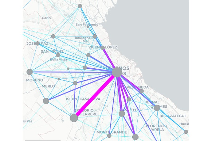
Map in Buenos Aires with points and public transport connection lines. Highlighting routes from the center to places like Vicente López, San Miguel, Merlo, and Avellaneda.
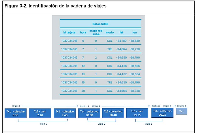
The image shows a table with travel data using a SUBE card, including time, mode (bus or train), and location. Below, a diagram details three trips and their transfers, starting at 6:30 and ending at 20:05.
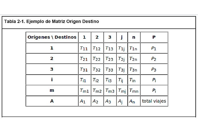
Origin-destination matrix table: rows and columns numbered with "T" to indicate routes between origins and destinations. At the end of each row is "P" and at the end of each column is "A", totaling trips.
Study on mobility patterns and inequality in public transportation.
Code4Dev: Learn about the Public Transportation OD Matrix
Analysis of trips in AMBA based on SUBE data (2019-2021).
Data on origins and destinations of trips by public transport (2019-2022).
Guide to building origin-destination matrices with data from the SUBE card.