
Language
HTML
Tool Type
API
License
Creative Commons Attribution 4.0
Version
2.0.0
Open Mobility Foundation

Mobility Data Specification (MDS) is a data standard designed to regulate the right of way and facilitate communication between local governments and mobility companies. MDS helps cities manage public transportation efficiently, standardizing interaction with mobility providers such as scooter and electric bike-sharing companies. This allows cities to implement and validate policies digitally, improving the management of public space and optimizing urban transportation.
MDS responds to the need to standardize urban mobility data management, facilitating the interaction between cities and mobility service providers. It provides tools to improve the regulation of public transportation and the use of public space, contributing to better urban planning and quality of life for residents.
**Unified Data Standards**: Provides a common data format for all mobility service providers. **Real-Time Data Sharing**: Facilitates the sharing of real-time data between cities and transportation providers. **Regulatory Compliance Tools**: Assists cities in enforcing local transportation regulations and policies. **Data Privacy Compliance**: Incorporates measures to ensure user data privacy and compliance with data protection regulations. **Traffic Management Insights**: Offers valuable insights for traffic flow optimization and urban planning. **API-Driven Integration**: Utilizes APIs for seamless integration with various urban mobility platforms. **Scalable Architecture**: Designed to accommodate growing data volumes and new transportation modalities. **Policy Development Support**: Aids in the development of informed and effective urban mobility policies.
Adopts RESTFUL API standards to facilitate data exchange. Uses JSON for standardized data representation. Implements encryption and secure protocols to ensure data transmission and storage. Leverages cloud technology to guarantee scalability and reliability. Ensures interoperability with various urban mobility services. Includes features for automatic compliance verification with local regulations. Promotes open-source development and collaboration.
Connect with the Development Code team and discover how our carefully curated open source tools can support your institution in Latin America and the Caribbean. Contact us to explore solutions, resolve implementation issues, share reuse successes or present a new tool. Write to [email protected]
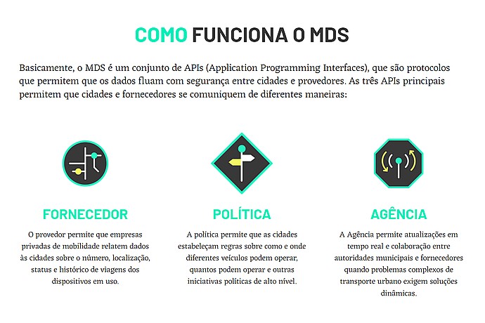
The image describes how MDS, a set of APIs that facilitate communication between cities and providers, works. It details the functions of three APIs: Provider, Policy, and Agency.
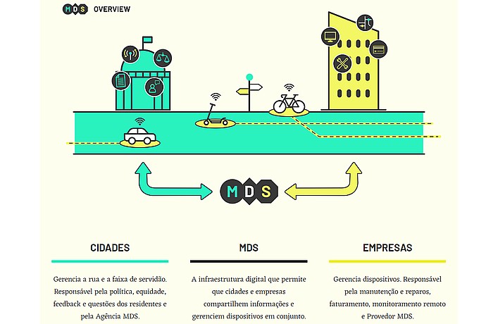
"Mobility Data Specification" chart showing interactions between cities, companies, and MDS. Includes urban mobility icons like digitally connected cars, bicycles, and scooters.
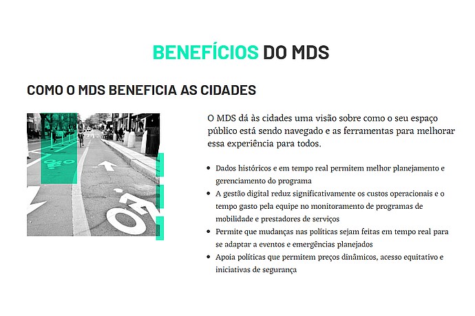
MDS benefits: Enhances public space management with historical and real-time data, reducing costs and adapting policies to events, promoting equitable access and safety.
Detailed information on MDS and its implementation to help cities manage transportation in the public right-of-way.