
Language
Javascript
Tool Type
Web app
License
AM331-A3
Version
1.2.0
Inter-American Development Bank

Data Extraction OSM simplifies access to maps and open data from Open Street Map, allowing navigation and extraction of detailed information for urban and territorial planning projects. This web application makes it easy to obtain specific attributes, supporting the closing of information gaps. Developed to increase planning accuracy using crowdsourced data, it is shared to allow public agencies and organizations to combine this data with existing records, improving their analytical capabilities with minimal effort and cost. It is a valuable resource for projects that seek to optimize the management of geographic information.
The OSM Data Extraction Tool addresses the lack of direct and easy access to detailed geographic data, allowing users to fill information gaps for territorial planning and analysis projects efficiently and at no cost.
Data Extraction: The OSM Extraction Tool offers tools for extracting specific geospatial data from OpenStreetMap. Customization: Users can often customize the tool to extract data relevant to their specific projects and applications. Geospatial Data Access: It facilitates access to OSM data for use in mapping, analysis, and geographic information system (GIS) applications.
Built with modern libraries like React, Redux, and Leaflet for geospatial data visualization and management. Uses OpenStreetMap data and converts it to GeoJSON, a widely adopted open standard. Employs tools like Webpack and Babel to ensure compatibility with modern JavaScript. Aligned with open development practices and standards for dynamic web applications.
Connect with the Development Code team and discover how our carefully curated open source tools can support your institution in Latin America and the Caribbean. Contact us to explore solutions, resolve implementation issues, share reuse successes or present a new tool. Write to [email protected]
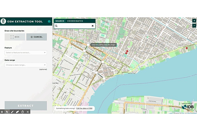
This image displays the interface of the OSM (OpenStreetMap) Extraction Tool, allowing users to draw boundaries and extract geospatial data from a map.
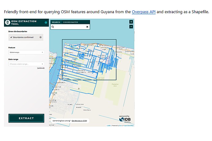
The image shows a digital tool named "OSM Data Extraction". Boundaries and the "Bodies of water" feature are selected to extract data near Guyana using Overpass API. There's an "EXTRACT" button.
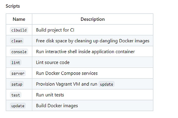
The image shows a script table with "Name" and "Description" columns. It includes: cibuild, clean, console, lint, server, setup, test, and update, with brief function descriptions.
Urban community mapping in Mexico and Argentina.
Support for housing strategy in Guyana.
IDB projects on urban planning and more.
It presents a set of open source tools from the IDB, including housing deficit estimation, to support urban planning in Latin America and the Caribbean.