
Language
Ruby
Tool Type
Web app
License
GNU General Public License version 3
Version
0.5.0
WINGU

Paths of the village is a web platform that facilitates access to information about urbanization processes in the towns of the City of Buenos Aires. It allows you to visualize the development of these projects and provides relevant data about the affected areas, using geolocation and citizen reports to collect, analyze and visualize data. This tool was born in response to the invisibility of the towns on official maps and the urgent need to highlight the deficits in public services and urban infrastructure. Caminos de la Villa becomes an essential means of citizen participation for monitoring urban works, improving transparency and promoting the inclusion of communities in the processes of improving their environment.
The platform addresses the need to improve communication and interaction between citizens and local authorities in urban areas, facilitating better management of urban problems and community participation.
Web-based platform for reporting and tracking urban issues. Interactive tools for community engagement. Integrated mapping and data visualization. Real-time updates and feedback mechanisms.
Built with Ruby 2.4.1, it ensures stable and efficient performance at all stages. Integrates advanced GIS technologies for precise map management. Implements robust user authentication systems and secure solutions for password protection. Optimizes file storage using AWS, adapting to current cloud trends. Follows the MVC model, providing an organized structure that facilitates scalability and maintenance, responding to changing business needs.
Connect with the Development Code team and discover how our carefully curated open source tools can support your institution in Latin America and the Caribbean. Contact us to explore solutions, resolve implementation issues, share reuse successes or present a new tool. Write to [email protected]
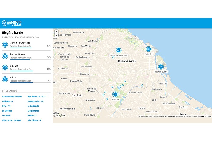
Buenos Aires map with urbanizing neighborhoods: Playón de Chacarita 53%, Rodrigo Bueno 50%, Villa 20 56%, Villa 31 56%. Options to select other neighborhoods.
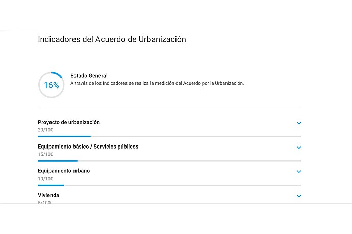
This image shows a dashboard of urbanization agreement indicators, with a progress bar for overall status and details on project, services, urban equipment, and housing progress.
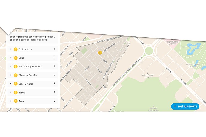
Map of a neighborhood outlined with marked streets. Left menu with options: Facilities, Health, Electricity and Lighting, Sewers and Drains, Streets and Squares (with a report), Trash, Water. Button "SUBMIT YOUR REPORT".
Active version of the tool in Buenos Aires
Article about improvements in Caminos de la Villa
Neighbors use the app to report urbanization
Official video about how the tool works