
Language
Python
Tool Type
Algorithm, API
License
AM331-A3
Version
0.30.0
Inter-American Development Bank

Pavimentados is a tool designed to identify faults in the pavement of roads and highways, in addition to vertical and horizontal signaling. It uses computer vision models to detect various elements on the roads, the results of which are used to generate key metrics for road maintenance planning. Developed to optimize and reduce costs associated with road maintenance and signal inventory, Pavimentados facilitates a more efficient and economical process. Its implementation seeks to support regional organizations and companies in improving road infrastructure, aligning with the objectives of digitalization and efficiency in transportation processes for 2025.
Managing infrastructure projects can be complex and challenging. Paved addresses this problem by providing a platform that simplifies and improves the management of road and pavement projects.
Project Management: Users can efficiently manage road and pavement projects, from planning to execution. Data and Asset Tracking: The platform offers tools for tracking project data and assets, ensuring accurate and up-to-date information. Documentation and Reporting: Users can generate project documentation and reports to streamline decision-making and reporting processes. Collaboration: Pavimentados supports collaboration among project stakeholders, enhancing communication and coordination. Customization: It can be tailored to meet the specific needs and requirements of infrastructure projects.
Utilizes Python to ensure compatibility with TensorFlow for AI model execution. Detects road faults and signage, evaluating conditions through advanced models. Supports images and videos as inputs for detailed analysis. Incorporates GPS data in open formats for precise localization. Eases installation via pip, allowing direct model download into the package's root.
Connect with the Development Code team and discover how our carefully curated open source tools can support your institution in Latin America and the Caribbean. Contact us to explore solutions, resolve implementation issues, share reuse successes or present a new tool. Write to [email protected]
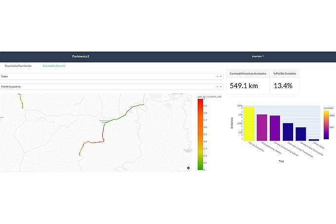
The "Pavement" interface shows a map with roads in green, yellow, and red, indicating pavement condition. It analyzes 549.1 km, with 13.4% "alligator skin".
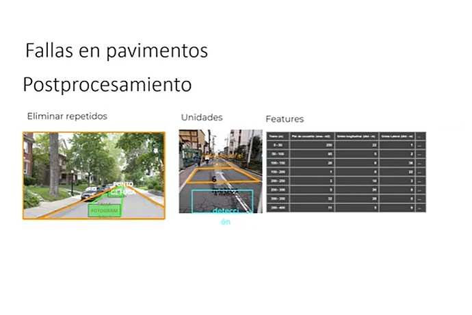
This image illustrates a post-processing technique for identifying and cataloging pavement failures using labeled images and feature categorization
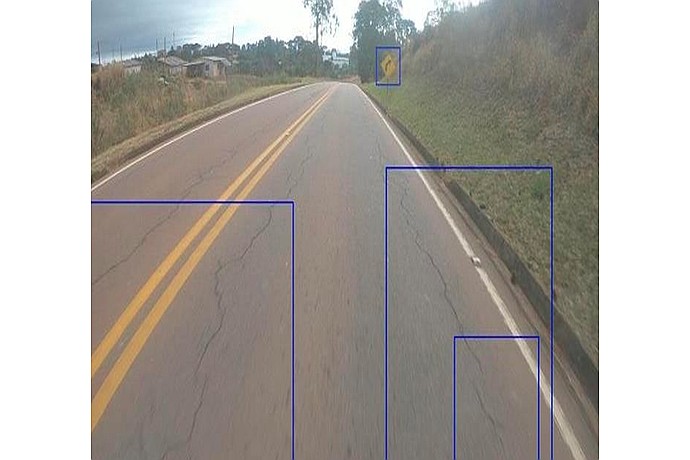
Asphalt road with yellow lines in the middle. Cracks are visible on the pavement. On the right, a square yellow sign. Blue boxes highlight elements in the image. Background with trees.
Details the implementation of Paving in Honduras and its impact on road infrastructure management.
Code4Dev: Get to know Paved
Presents Paved updates, improving its efficiency and usability in road analysis.