
Language
Python
Tool Type
Mobile app, Web app, Spreadsheet, Plugin, Manual
License
AM331-A3
Version
1.0.0
Inter-American Development Bank

Sanihub Basic Network is a QGIS plugin focused on sewage and treatment plants. It facilitates the design and management of healthcare infrastructure through specialized modules. This tool is part of the SaniHUB initiative, a set of open source tools integrated into QGIS to design efficient sanitation systems. Created to disseminate innovative methodologies and provide access to modern technologies in healthcare design, SaniHUB supports the design and management stages of sanitation systems. It is an initiative supported by international organizations to improve local capabilities in developing countries.
SaniHUB Basic Network improves access to modern tools for the design of sanitation systems, facilitating the planning and execution of efficient and sustainable health infrastructures in communities with limited resources.
Integrates geospatial data for precise urban sanitation planning. Utilizes macro-enabled spreadsheets for dimensioning and calculations. Supports multiple languages, ensuring accessibility and inclusivity. Offers a user-friendly interface for efficient data input and management. Leverages Python scripts for data migration and backend functionalities.
Utilizes Python for backend development, enabling script automation and data processing. Integrates Excel spreadsheets with macros for complex calculations, leveraging VBA alongside Python. Incorporates geospatial data functionalities using libraries like GDAL. Implements internationalization support, ensuring global accessibility. Structures a robust user interface, potentially using frameworks like Flask or Django for web applications or PyQt or Tkinter for desktop applications.
Connect with the Development Code team and discover how our carefully curated open source tools can support your institution in Latin America and the Caribbean. Contact us to explore solutions, resolve implementation issues, share reuse successes or present a new tool. Write to [email protected]
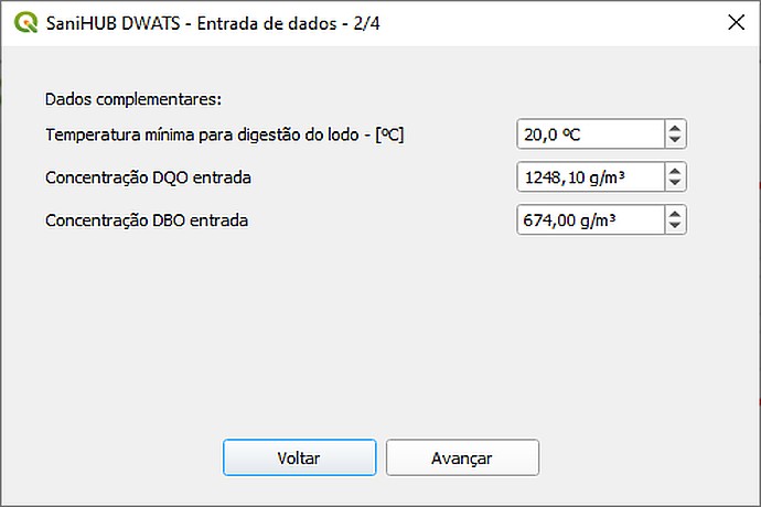
"SaniHUB DWATS - Data Entry - 2/4" screen. Data: minimum sludge digestion temperature: 20.0 °C, COD concentration: 1248.10 g/m³, BOD concentration: 674.00 g/m³. Buttons: Back, Forward.
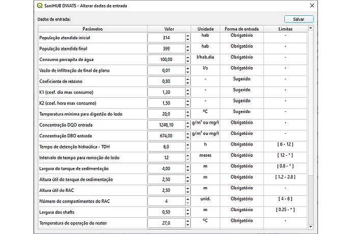
The image shows an input data table for "SaniHUB DWATS", including initial served population (314 hab), water consumption (100 l/hab.day), and reactor operating temperature (27.0 °C).
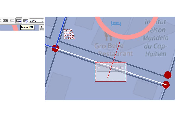
Sanihub Basic Network interface displays a map with intersecting blue and white lines, text: "CT: 0.60, CT: 6.7, CF: 5.63, h: 1.07m". "Move ETE" button and "Gro Belle Restaurant" name visible.
Digital repository that promotes open technologies for water, hygiene and sanitation services.
Presentation of the tool and its functionalities in healthcare design with QGIS.
Technical Cooperation to promote a new sanitation paradigm in Latin America and the Caribbean.
Video lessons explaining how to use SaniHUB RedBasica in real projects.
Introduces the SaniHUB initiative as part of the regional sanitation approach.