
Language
Python
Tool Type
Desktop app, Algorithm, API
License
GNU General Public License version 2
Version
1.0.0
LLACTALAB

SISURBANO explores urban form and its relationship with urban sustainability. This tool allows evaluating various sustainability conditions in each urban fabric, providing quantitative data on the relationship between sustainability and urban morphology. Developed in response to the growing need for awareness about climate change and natural disasters, SISURBANO seeks to encourage the development of proposals that improve quality of life and ecological sustainability.
SISURBANO addresses the need to understand and improve urban sustainability, facilitating the assessment of sustainable conditions and the generation of data to support more effective public policies.
Data Collection: Collects urban data from various sources, including sensors, surveys, and satellite imagery. Data Integration: Integrates disparate urban data into a unified platform for analysis. GIS Mapping: Provides geographical information system (GIS) capabilities for mapping and spatial analysis. Data Visualization: Offers interactive visualizations to help stakeholders understand urban trends and patterns. Infrastructure Assessment: Allows assessment of urban infrastructure to identify areas in need of improvement. Transportation Planning: Supports transportation planning and optimization for efficient urban mobility. Housing Analysis: Analyzes housing data to address housing-related challenges and affordability. Environmental Monitoring: Includes environmental data to support sustainability and environmental management. Stakeholder Collaboration: Facilitates collaboration among city planners, government agencies, and citizens. Policy Insights: Provides insights for evidence-based urban policy development. Open Source: Released under an open-source license to encourage collaboration and customization.
Leverages geographic information systems to efficiently integrate and analyze spatial data. Developed in Python, it harnesses its capabilities for data processing and analysis. Designed to be compatible with QGIS 3.10.2 or higher, ensuring interoperability with a free and open-source GIS system. Utilizes the Pandas library for advanced data manipulation. Provides an open-source framework, encouraging community contributions and improvements.
Connect with the Development Code team and discover how our carefully curated open source tools can support your institution in Latin America and the Caribbean. Contact us to explore solutions, resolve implementation issues, share reuse successes or present a new tool. Write to [email protected]
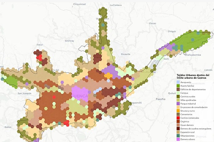
Cuenca, Ecuador map displays various urban fabrics in different colors: airport, family orchard, campus, expansion areas, and checkerboard patterns, among others, indicated in a legend on the right.
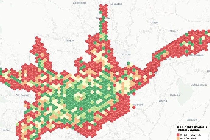
Hexagonal map shows the relationship between tertiary activities and housing. Green indicates good, yellow medium, and red poor. Examples: Chiquintad, Gualaceo, Paccha in the image.
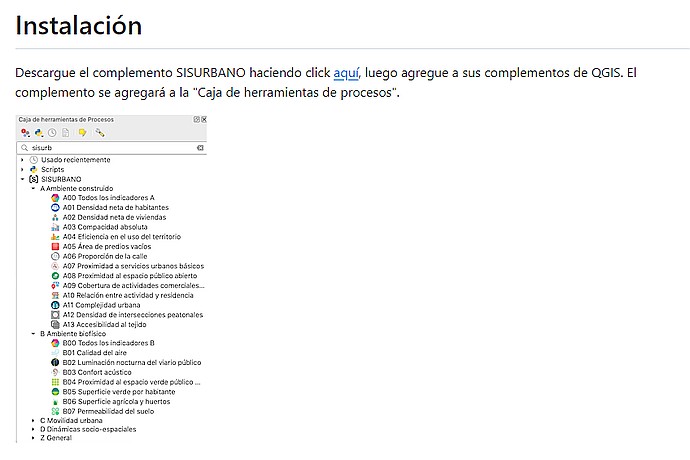
This image depicts a screenshot of installation instructions for the SISURBANO plugin for QGIS, with a glimpse of the plugin's process toolbox structure.
Platform to evaluate sustainability in urban fabrics through spatial indicators.
Detailed guide on the installation and use of the tool.