
Language
VBA
Tool Type
Spreadsheet
License
AM331-A3
Version
1.0.0
Inter-American Development Bank

Smart maturity assessment tool is a tool designed to measure the maturity of cities in aspects such as mobility, environment, economy, and more. It evaluates the global maturity of the city and the specific maturity of each dimension, including capabilities and resilience. Created by the IDB and Deloitte, this tool adapts to the realities of Latin America and the Caribbean, allowing cities to evaluate their maturity to become smart cities and discover areas of opportunity.
This tool resolves the lack of methodologies adapted to Latin America to evaluate the smart maturity of cities, providing a clear framework for self-assessment and continuous improvement in various urban aspects.
Maturity Assessment Framework: The platform offers a structured framework for assessing the maturity of smart city initiatives, encompassing various dimensions such as governance, technology, and citizen engagement. Benchmarking: Users can compare the maturity levels of their initiatives against industry standards and best practices. Data Collection: The tool supports the collection of data and information related to smart city projects, including key performance indicators (KPIs) and success metrics. Evaluation Reports: Users can generate reports summarizing the assessment results and providing recommendations for improvement. Customization: The tool is customizable to align with the specific smart city assessment needs of different cities and regions. Documentation: Comprehensive documentation available on the platform's website assists users in conducting maturity assessments effectively.
Uses advanced spreadsheets (.xlsm) to analyze city data and calculate maturity levels. Integrates databases, graphical interfaces, and scoring algorithms across various dimensions.
Connect with the Development Code team and discover how our carefully curated open source tools can support your institution in Latin America and the Caribbean. Contact us to explore solutions, resolve implementation issues, share reuse successes or present a new tool. Write to [email protected]
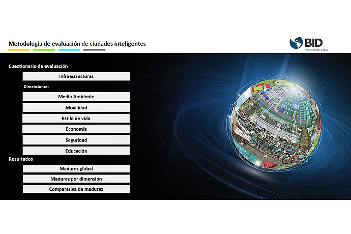
This image displays a graphical user interface for a smart city evaluation methodology, featuring a questionnaire and results categories like environment and mobility.
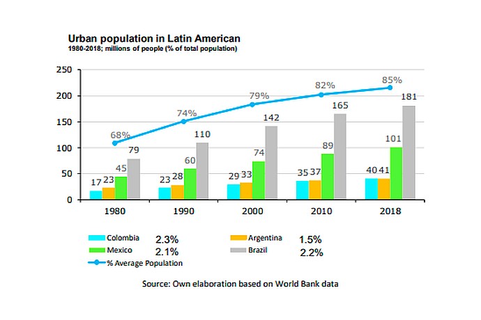
Bar chart of urban population growth in Latin America (1980-2018) showing increasing percentages: 68% in 1980 to 85% in 2018. Data from Colombia, Mexico, Brazil, Argentina. Source: World Bank.
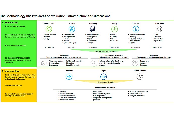
This image outlines a methodology for evaluating urban infrastructure and dimensions, including environment, mobility, economy, safety, lifestyle, and education, with associated criteria and technology considerations.
Detailed guide to apply and use the tool.
Explains how to measure maturity to become a smart city.
Supports the measurement of maturity of smart cities in LAC.
IDB unveils methodology assessing city smart maturity, identifying opportunities, projects, financing, and implementation steps, priorities.