
Language
Python
Tool Type
Plugin
License
AM331-A3
Version
1.0.0
Inter-American Development Bank

Urban Land Valuation is a model developed to predict the appreciation of land near public works using market prices. Based on pre- and post-construction data, the model identifies “difference maps” that show changes in land value based on the distance of properties from the construction site. This tool allows municipalities to carry out assessments and predict the impact of similar works on surrounding properties, thus improving urban planning and resource management.
Urban Land Valuation addresses the need to anticipate the economic impact of public works on urban land values, providing a tool to effectively estimate and plan property valuations, crucial for urban development and taxation.
Parcel Assessment: Urban Land Valuation allows users to assess individual land parcels, considering factors such as location, size, and infrastructure availability. Valuation Models: The tool incorporates valuation models to estimate the market value of land based on various criteria, helping users make informed pricing decisions. Land-Use Planning: Users can explore different land-use scenarios and their impact on urban development. Data Integration: The tool supports the integration of geospatial and property data to enhance accuracy in land valuation.
Compatible with geospatial and property data, this tool enables evaluation of urban parcels based on location, size, and infrastructure. It incorporates valuation models to estimate market prices under multiple criteria. Supports exploration of land-use scenarios and their urban impact, following open standards for territorial analysis.
Connect with the Development Code team and discover how our carefully curated open source tools can support your institution in Latin America and the Caribbean. Contact us to explore solutions, resolve implementation issues, share reuse successes or present a new tool. Write to [email protected]
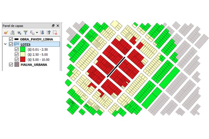
Urban plot map with colors: green ($0.01-2.50), yellow ($2.50-5.00), red ($5.00-10.00). Streets are visible and a layer panel on the left shows the legend.
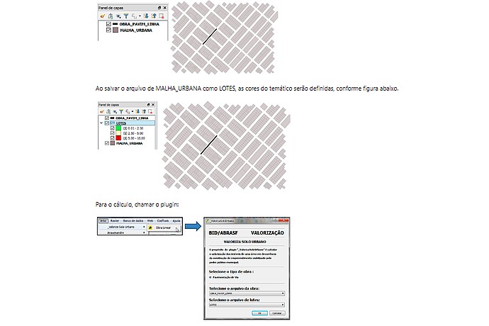
The image shows a layer panel in a GIS software, handling a "MALHA_URBANA" file. When saved as "LOTS", colors are defined. The "VALORIZATION" plugin is used for calculations.
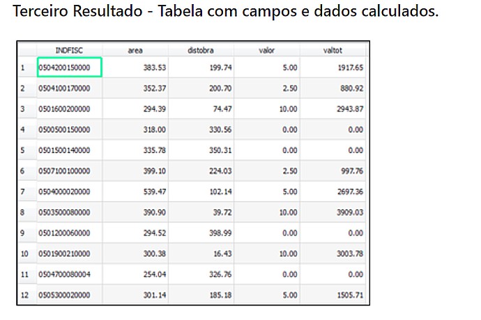
Table with columns: INDFISC, area, distobra, value, and valtott. Includes data like INDFISC 050420015000, area 383.53, distobra 199.74, value 5.00, and valtott 1917.65, among others.
Project on digital solutions for tax administration.
Analysis of capital gains capture and its impact on urban development.