
Language
Python
Tool Type
Algorithm
License
AM331-A3
Version
0.2.4
Inter-American Development Bank

Urbantrips, an open source library, transforms data from public transportation payment systems into detailed trip analytics. By inferring destinations and building trip chains, it generates origin-destination matrices and KPIs for buses. Its goal is to offer valuable tools for transportation management with minimal prior information. From a single table of geolocated transactions, Urbantrips produces accurate results that improve with additional information. This process creates trip matrices, key indicators and visualizations such as graphs and maps, facilitating decision making in public transport management.
Transportation agencies within local governments in small cities do not always have the resources necessary to process electronic payment card data and turn that data into valuable inputs for public policy. They either lack the human resources to collect data and perform custom analysis or cannot afford private licenses for expensive software. Complex transportation modeling also requires a large amount of data, with inputs that are not always available or difficult to collect, process, and load into the model. However, several cities already have an electronic payment system on their public transport. Urbantrips can help those cities take advantage of that data and get easy, cheap, fast, but powerful and up-to-date information.
Data Analysis: UrbanTrips often includes tools for analyzing transportation data, such as traffic flows and commuting patterns. Visualization: The platform supports data visualization, enabling users to create maps and charts that illustrate urban mobility trends. Policy Planning: Users can often use the insights gained from the data to inform urban transport policies and improvements.
Developed primarily in Python, it leverages its versatility and efficiency. Utilizes Jupyter Notebooks for demonstrations, facilitating understanding and interactive usage. Processes large datasets of transit payment transactions, inferring travel patterns accurately. Integrates geographic information to enhance data analysis. Designed to support public transportation planning, it requires minimal data preprocessing, promoting interoperability and the use of open formats.
Connect with the Development Code team and discover how our carefully curated open source tools can support your institution in Latin America and the Caribbean. Contact us to explore solutions, resolve implementation issues, share reuse successes or present a new tool. Write to [email protected]
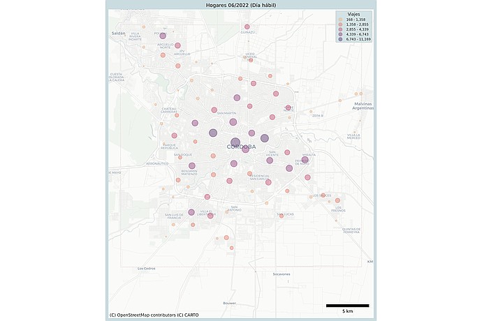
Cordoba map with circles of various sizes and colors. Indicates "Households 06/2022 (Workday)". The legend shows travel ranges from 168 to 11,169. 5 km scale.
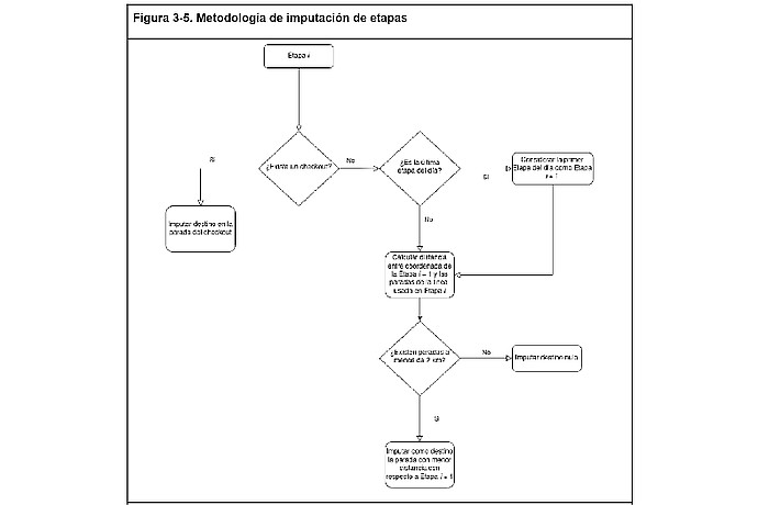
Figure 3-5 shows a flowchart titled "Stage Imputation Methodology" including decisions like "Do you have a chococard?" and "Is it the last stage of the day?" with imputation options based on stops.
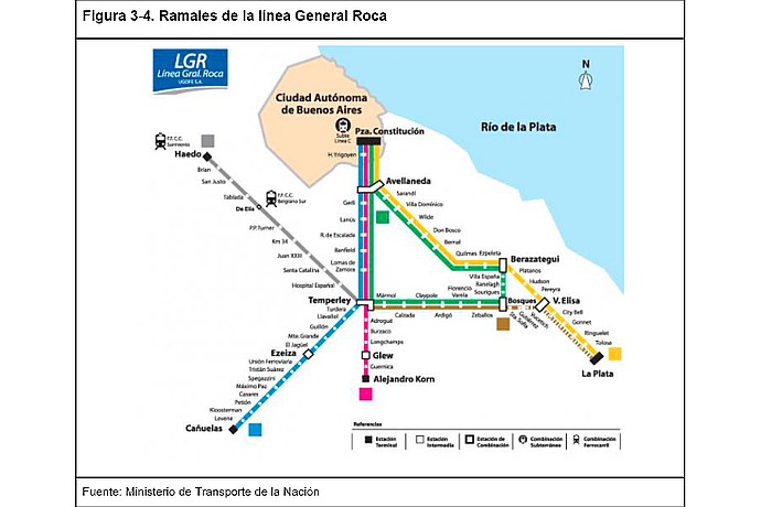
Map of the General Roca Line train branches, showing connections from Plaza Constitución to areas like La Plata, Ezeiza, Alejandro Korn, and Haedo. Source: Ministry of Transport.
IDB project RG-T3592 that frames the development and implementation of Urbantrips in the region.
Code4Dev: Learn how to implement the Urbantrips open source tool
Detailed guide on the installation, configuration and use of Urbantrips.